Hi everyone. Happy Tuesday and Happy T day to you.
I'm joining all the lovely ladies over at Bleubeard's and Elizabeth's blog for our Tuesday T post.
Several of you mentioned last week that you hoped I would show some more trip photos for T this week, so I will. Smile. (And I apologize this is a bit of a long post.)
We always stop and take photos at the National Park signs, so here is me at our first National Park of the trip. That is why my finger is raised, to designate this is park #1. You might remember I mentioned Great Basin National Park is just over the Nevada Line, very close to Utah. It is so close that to get to the park from our hotel ( which was also in Nevada and that I showed you last week on T day) we had to drive from Nevada into Utah and then from Utah back to Nevada to arrive at the park. We also had to keep in mind there is a 1 hour time change between these 2 states.
One of the main attractions in Great Basin is Wheeler Peak.
You can drive up to 10,000 feet /3048 meters. At this point, there is a parking lot. From there you can hike. The biggest attraction is to hike to the bristlecone pines.
photo courtesy of the website for Great Basin National Park
Here's a bit of what Wikipedia says about the bristlecone pine trees:
The term bristlecone pine covers three species of pine tree (family Pinaceae, genus Pinus, subsection Balfourianae). All three species are long-lived and highly resilient to harsh weather and bad soils. One of the three species, Pinus longaeva, is among the longest-lived life forms on Earth. The oldest of this species is more than 4,800 years old,[1] making it the oldest known individual of any species.
I was really interested in seeing these trees. Now the distance to them is not too far (only 1.5 miles /2.4 km up or 3 miles/4.8 km round trip on the direct trail or a little longer on the Alpine Lake trail), but for me, starting the hike at 10,000 feet was going to be a challenge. There is no place in New Hampshire with that elevation. In fact, my house is probably at best maybe 700 feet/213 meters up in elevation from sea level. Since this was our first park, we really didn't have a lot of time to adjust to the altitude difference.
I was keeping hydrated, and I am used to walking several miles a day, so we were going to give it a try. I was a little more concerned about my husband, but as he kept saying, slow and steady wins the race.
Up we went.
There were some amazing views, but you should take notice those dark clouds filling in the sky in this next photo.
I must say on the way up, I did have to stop and catch my breath several times. (And luckily I never needed my asthma inhaler).
Earlier along the trail, there was a split. If you went straight, it was 1.5 miles (2.4 km) up to the bristlecone pines. If you went to the right, past the alpine lakes, it was a bit longer.
We were going to head straight, and then several people who started hiking when we did, mentioned it was a steeper climb. We took their advice and off we went on the right hand trail towards the lakes.
We came to the first alpine lake. The water in the lake was low, but it was still a pretty spectacular view.
Notice the sky was darker now, but a little rain wasn't an issue, so we continued along the trail towards the turn off for the bristlecone pines. The bristlecone pines grow further up just beyond the treeline, in an area that is pretty wide open. This lake, as you can see, was still just within the treeline.
Here's a photo from along the next leg of the trail.
And then, just before we reached the second alpine lake, we heard a loud rumble of thunder. And then another. And then we had a bit of light rain.
Being at the furthest point of the trail, there was nothing to do but keep walking. At least we were under the cover of the forest around us.
And we came to the second alpine lake (there were 2 total). This one was really dry.
And we continued along the trail.
We finally reached the split in the trail where there was a sign directing us further up the mountain to the Bristlecone pines.
I was hopeful that the storm had passed and that we could head up to the pines because we hadn't heard any more thunder in a while. Yes it was raining lightly, but the rain we were in wasn't exactly dangerous. (Like lightning that goes with the thunder would be.)
And then, just as we stood at the base of the Bristlecone pine trail, we heard the loudest boom of thunder of them all. My husband and I looked at each other. There was no real safe cover up at the Bristlecone pines, and we had been told by a ranger that morning not to go up if it was thundering. My husband said to me "There's our answer." (whether we should head further up or to continue on back to the car).
And he was right, so we continued along the Alpine Lake trail, now going down towards the parking lot.
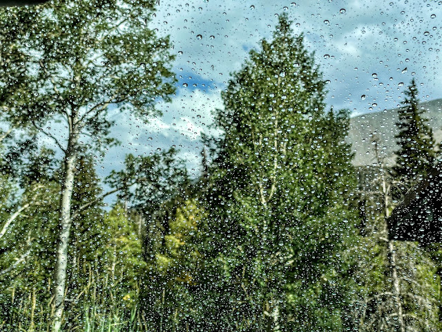
And even though we had to dash through the rain to get to the car when we got out of the forest, of course, within a few minutes the sky was brightening.
You can see all the drops of water on the windshield before we started the car as well as the sun coming back out.
All I can say is that it makes another good travel story.
We were so close. And still so far.
(And if you didn't see but are interested, I did a post this past Saturday on the caves we visited in the park also.)
OK, I can't forget that this is a T day post and I need to share a drink. I never took a photo of my water jug while hiking. Yet before our hike, while at the visitor's center, we had a sandwich and a drink. Most visitor centers don't have restaurants, but this one had a small one, so we decided to fuel up before our trek.
You can see my unsweetened ice tea, my grilled cheese BLT sandwich with avocado, as well as the homemade potato salad side that came with my sandwich.
Thanks for making it this far through the post. I hope you have a happy T day and week ahead.


