Showing posts with label New Hampshire photos. Show all posts

Saturday, October 15, 2022

Foliage

 Hi everyone. Happy Saturday to you.

Today is my husband's and my 34th wedding anniversary. We're talking about doing something for the day, maybe drive up north to the mountains to leaf peep before all the leaves have fallen off the trees (if our heavy rains the  last 2 days didn't drop them all already) or maybe head down to the ocean for a beach walk. Since this post goes live early in the morning, we shall see what actually happens. 

In the spirit of the day, let me share some photos from my area this past week, before we had rain the last 2 days.


Views from my driveway the other morning.


And the view from the side of my house that looks into the woods.


And here's a wide angle view I took a few days earlier.


I snapped a few photos through the front windshield on our long way around drive home from the dump last Sunday.


And here's some wild turkeys who were hanging out in and on the sides of the road. This is the first of 2 rafters or flocks we passed that day.


I still have some roses blooming in my yard. It's great to have them, even if they aren't quite as big or well put together as the blooms I had during the summer.


And one last photo I took a little over a week ago when I walked with some friends along the Dover rail trail. The trail parallels the Cocheco River.

Yes, nature is putting on a wonderful show right now.

Enjoy your weekend.

Friday, October 9, 2020

Lines of Sight

 Happy Friday everyone! Monday through Friday went from start to end in a blink of an eye, and now it is almost the weekend.

Today I have a page for Chris' challenge at Art Journal Journey. Chris has asked us to Hold the Line this month, and my page today is about lines of sight. I drew 5  lines of sight on my page to represent ways you might observe the house, but of course 9as you know)  there are far more depending on where you are standing when you look at the house. You will have to use your imagination to see the view from each of those directions I did include. And the front of the house that I show you has no drawn lines for that sighting, but of course is the line of the sight you see.

But as you also know, drawing it as I want is the joy of art journaling-smile.


Here's the quote. 


I thought I would also share a few more photos from my walk  at Odiorne State Park with my daughter the other day.

Here's inspiration photos for my art today. 


I have wanted to walk out on this jetty for as long as we have been boating and anchoring out at the beach.  The view of the jetty from the boat looks really different. Below is a view from the boat I took back in the summer on a warm, calm day. 


When my daughter and I  walked the other day I planned on walking out on the jetty. 


Only... the tide was very high and still 30 minutes from highest tide, plus there were several waves breaking over it. Not wanting to be washed out to sea (smile) or getting my feet drenched, I figured it would be better to wait until one day when the tide was low and the sea was calmer.  Plus getting over that  watery pool close to the front of the photo looked a bit tricky.
And here's a slightly different view of the jetty, or another line of sight.


And a few more ocean photos for you.  This is the beach where we often anchor our boat. The tide was high enough there was no beach at all.


And the bridge over a river in the salt marsh to get out to the harbor. 


Enjoy whatever you have left of your Friday and the start of your weekend. 


Saturday, October 3, 2020

Another Road Trip-Part 2

 Hi everyone. I should call this post More of the White Mountains. 

You might remember my post from last Saturday when I wrote about a one day road trip my husband and I took to the White Mountains of New Hampshire. (Here's the post in case you missed it and are interested in reading it: Mount Washington).  Last week I showed you photos of Mount Washington. Today I want to share some other views with you from my day out.


If you are driving north from my house, you pass Mount Chocorua before you get too far north. This mountain has a distinctive shaped peak. 
According to Wikipedia:
Chocorua's summit is a picturesque rocky cone, and the mountain is purported to be one of the most photographed in the world.[3] The view from Chocorua Lake, which often casts a reflection of the mountaintop, was chosen to represent the White Mountain National Forest on a quarter issued by the U.S. Mint in 2013 as part of its America the Beautiful coin series.[4]

I wish the lake was a bit calmer for a lake reflection, but there was some wind that day. Yet you can see the famous tip, and the blue skies were fantastic.

Here's a nice view looking out from a rest area in North Conway, but not of Chocorua. Even though this was only 2 weeks ago, you can see there wasn't much color in the leaves then.


New Hampshire has several mountain notches (or narrow mountain passes) in the White Mountains. We drove through Crawford Notch. It is a favorite of mine. The views are beautiful, but maybe not the most dramatic. What  I really like how it feels wild and rugged. I also like how the road twists and turns. It really feels like a notch.


We stopped at the area called the Willey House and took a short trail walk. 


This area is called the Willey House because of tragedy that occured here. 


Drawing by W. H. Bartlett of the Willey House, Crawford Notch. Once the home of Ethan Crawford, it later became a tourist attraction following a storm in 1826 which resulted in the deaths of the Willey family and others.

And also from Wikipedia:

Northern New England experienced a drought in the summer of 1826, which ended with the arrival of a terrific storm on the evening of August 28. Flooding followed, with the valley at Crawford Notch being one place that suffered the consequences. All but two of the bridges on the turnpike that ran through the notch were destroyed, trees suffered a similar fate and the high sides of the valley were gouged by swollen streams and landslides. The Willey House was a scene of desolation due to the effects of an avalanche on a mountain behind it. The house, however, had survived in an island of calm because the surging debris split either side on a low ridge and then unified again beyond it.[1]

Local residents, including Ethan Crawford and the Reverend Benjamin G. Willey, Samuel's brother, visited the house in the aftermath of the storm. It was empty, with signs that there may have been a rapid departure from it, such as unmade beds, clothes strewn around and ashes in the fireplace.[1] There was an open Bible on the table.[3] A search of the devastated area over the next few days revealed the bodies of the Willey parents, two of their daughters and two hired hands; the remains of the other three Willey children were never found.[1] Some livestock had also been killed, including those in a now-destroyed stable.[3]

There followed various theories as to what had happened, the most likely of which is that the occupants abandoned the property as the avalanche approached but in doing so, in darkness, they unwittingly put themselves in the path of it around the point where the flow reunited.[1]


It is a sad story and even more sad that the area became a tourist attraction because of this event. I guess no different than today, but what a strange trait  curiosity can be sometimes. 

And here's a few more road trip photos through Crawford Notch.


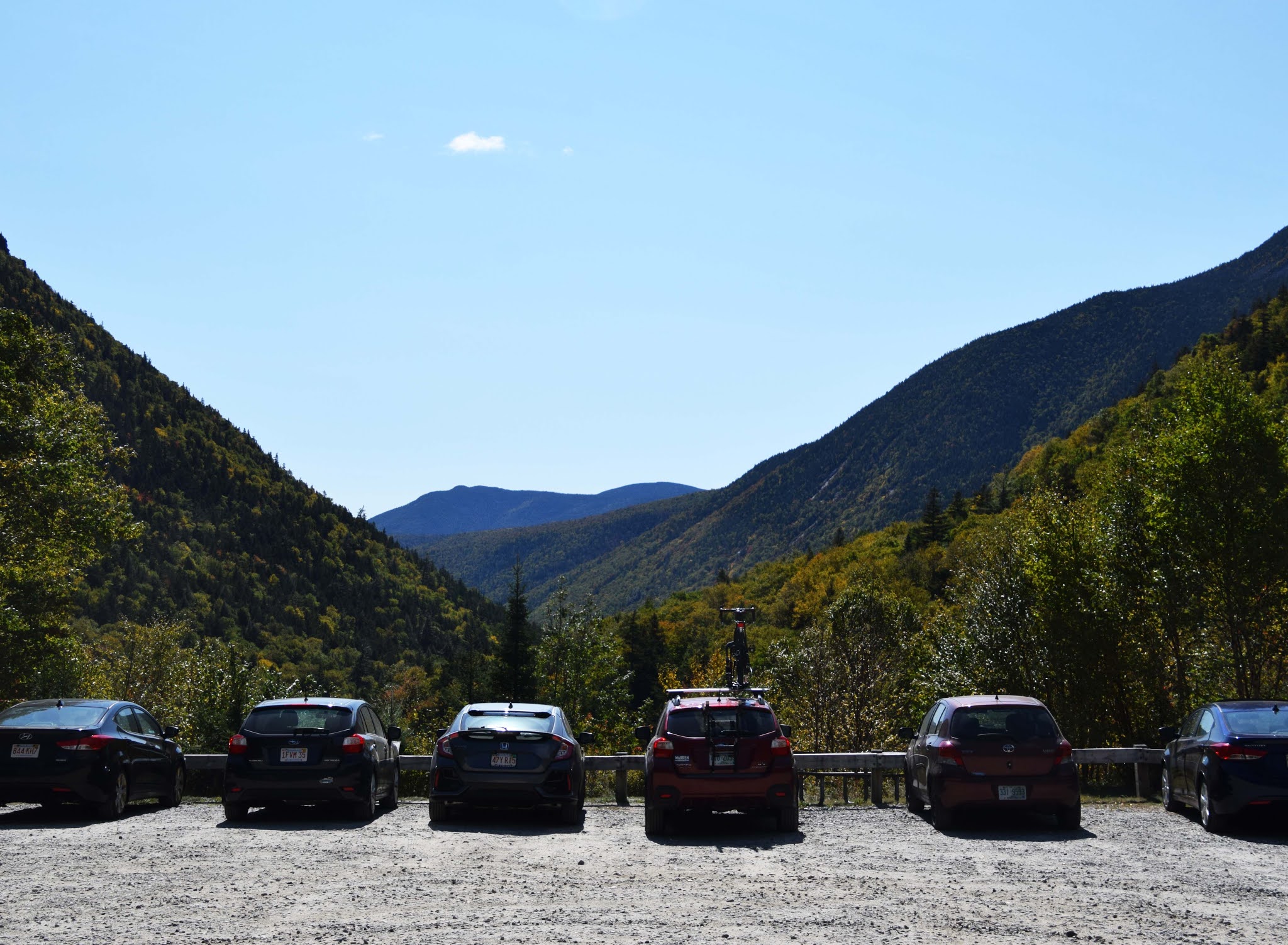
This parking lot photo was taken in the northern end of the notch, and you  can see why it is a notch. The road goes through that narrow mountain pass you can see.

On our way home we saw a sign for Bear Notch. We had never  heard of Bear Notch, so we quickly checked it out and decided we should try it. 
Bear Notch Road is only open part of the year. It did have some pretty views. 


Perhaps you can spot the pointed cone in the distance of Mt. Chocorua. It is the clear point in the back of all the other mountains.
Besides the great views, the Bear Notch road cut off the heavier traffic through a couple of touristy towns and took us down about half way home. It was a good find!

Those are all my road trip photos (I was the driver that day and had to stop to get any photos), except for my lunch which I will share with you Tuesday for T. Hope you enjoyed them and a little bit of New Hampshire history too.

Happy weekend!

Saturday, September 26, 2020

Another Road Trip-Part 1-Mount Washington

 Hi everyone. 

Last week ended with some wonderful weather on Saturday. It was crisp (I actually needed my down vest), but clear clear blue skies. A perfect day for nice views.

If you stop by my blog frequently you might have read that last week I took a ride with my husband to his meeting in Northern Vermont. He was going alone and his meeting was going to be short, and for me, it was great to "go" somewhere out of the ordinary.

In fact, my husband and I both enjoyed going someplace different that we decided this past Saturday to go for another drive and see some different scenery. This time we headed north in our own state of New Hampshire and head into the White Mountains.

 The White Mountains are a mountain range covering about a quarter of the state of New Hampshire and a small portion of western Maine in the United States. They are part of the northern Appalachian Mountains and the most rugged mountains in New England. (from Wikipedia)

We live on the eastern side of  the state and decided not to drive  across the state.  That meant we headed out and drove a couple of hours in a more or less northerly direction.

Just north of the town of  North Conway the road splits, and you have a choice. If you head  northeast, you will go through Pinkham Notch.  If you head northwest, you will go through Crawford Notch. In between these 2 notches is the mighty Mount Washington.

Mount Washington is the highest peak in the northeastern US at 6288 feet (1917m).  I know that's not very high compared to a lot of mountain ranges, but the Appalachians, of which the White Mountains are part of , are one of the  oldest mountain ranges on the planet. Therefore they are really eroded.

  Mount Washington is notorious for its erratic weather. On the afternoon of April 12, 1934, the Mount Washington Observatory recorded a wind speed of 231 miles per hour (372 km/h) at the summit, the world record from 1934 until 1996. Mount Washington still holds the record for highest measured wind speed not associated with a tornado or tropical cyclone. (Wikipedia)

OK, if this post has been a bit heavy reading, I just wanted to give some background info. We headed in the northwest direction., through Crawford Notch and beyond to Coos County where this big mountain is located.  Today I am going to share the mountain with you.

Here's the western view of Mount Washington. On the left  side you can see the railroad that goes up this side of the mountain. The towers on the top are for the weather station. The scars in the middle and right side are from avalanches, rock slides and water run off caused erosion.


The railroad that goes up Mount Washington is called the Cog Railway. We didn't ride it up that day. It is pricey, and really one of those things you only need to do once.  I had gone up with my family when my daughter was younger, and we were doing a local vacation. 
Plus although the temperature was around 52 degrees F on the bottom, on the mountain top it was only 26.9 degrees F.  And we had some wind too. So as chilly the as the bottom was, the top was cold.


Never mind the wind.
But it is fun to watch the trains. So we took a ride up and went out to see what was happening.


W did walk through the tiny free museum. When we arrived there were few people around, so we had the museum to ourselves. 

Here's one of  the trains on the way down.


When we rode the train it was still coal burning. Not the cleanest burning, but definitely historic. Now they have changed over to biodiesel. And at least the passengers aren't showered with black smoke and coal dust anymore.


We had a great view looking west from the parking lot. It was nice to just sit in the car for a little while, enjoying the warmth and sunshine. And the view too.

Another famous spot on the western side of Mount Washington is this vintage beauty.


The Mount Washington Hotel 

Some day I should like to come and stay here. But this trip was just a day out adventure, and with Covid, I am not yet ready to stay in a hotel yet.

The hotel was originally built between 1900-1902.  Originally the hotel was only open in the summer, but recently it was bought out by a hotel corporation and it is now open year round. There is a large ski area right down the road, and I think they also now own the hotel. I wonder what it's like inside? 
Maybe one day I will be able to tell you.

That's all for me today. I hope you enjoyed your virtual road trip.
Thanks for stopping by!


Monday, July 30, 2018

A Trip Down Memory lane

Happy Tuesday all my T Day friends and visitors.
 First I would like to share the cool ATC I received from Deb for the T Day celebration a couple of weeks ago.

 And this fun little package of goodies was included.
Thanks Deb for this great ATC and little package! You were an awesome swap partner.

So today for T Day I want to share my lunch from last Saturday. My husband and I took a 2 hour trip out to visit our daughter who lives on the opposite side of New Hampshire from us. We live on the east side of the state near Maine, and she lives on the west side of the state near Vermont.
When I was a kid, my grandmother had a little cabin in the woods in southwestern New Hampshire near where my daughter lives.  I used to go stay with her during the summer (the cabin was strictly seasonal) and I have really fond memories of those visits.
A couple of months ago my daughter told me how she'd gone to eat at this place that is now called Kimball Farms but used to be called Silver Ranch. This was one of places we used to go have ice cream or a rare dinner out when we went to visit my grandmother at her cabin. I told my daughter I wanted to go there one day this summer and take a little trip down memory lane.
This past Saturday was the day.
When I arrived I was surprised to see how much things had not changed. It's been a lot of years since I had been there. I won't mention how many years, but it has to be  since disco  and those funky platform shoes  were the hot trends. 
You went up and ordered at an outdoor window and then you could either eat outside at a picnic table or inside at a slightly fancier  picnic table.
Even the inside looked the same.
 In all my excitement I almost forgot to take a photo of my lunch. I had  a tuna sandwich on rye with coleslaw as my side. All plates came with a slice of watermelon, and in my green cup was a diet coke.
After lunch I took my family on a little drive around to check out some of the places I remember from my childhood.
The beach on Lake Contoocook where I used to go swimming.
 And a quick stop at the Cathedral of the Pines. The Cathedral of the Pines is an outdoor nondenominational church that was built by a family after their son was killed during World War 2. There are also some walking trails which is what we used to do with my grandmother. 

In the church area is this great view of Mount Monadnock. This is the second most climbed mountain in the world behind Mount Fuji in Japan. I think it is so popular because it is not very high ( a little over 3000 feet or 965 meters), has several trails to the top ranging from fairly easy to more difficult,  has a great view from the top , and is in an area where it is accessible to a large population base. I climbed it once as a kid, and think maybe I need to do it again sometime.
This house has no connection to me but it  is a good view of how pretty this area is.
And after our little drive, we stopped and got some ice cream.
This is back at Kimball Farms.  I had a lot of ice creams here as a kid.
Stop by  Bluebeard and Elizabeth's blog  to see what food, drinks and fun the T gang has to share.
Thanks for visiting.